The Active Volcano in Oregon; Davis Lake
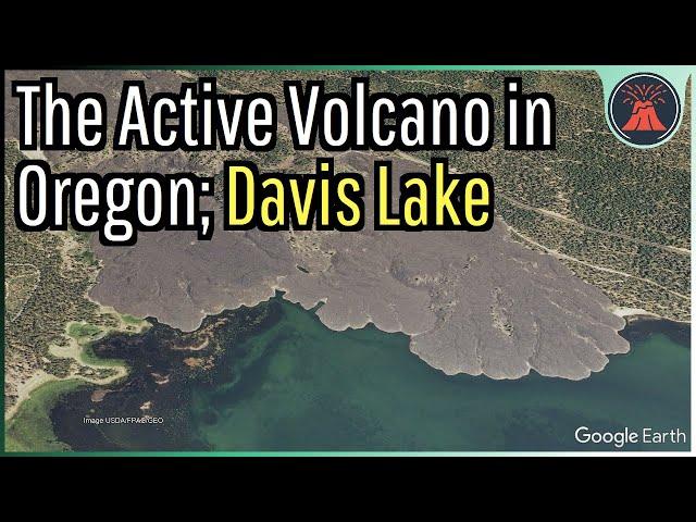
Within Oregon is a little known but still active volcano which a mere 5,000 years ago produced a series of 300 foot tall lava flows. These lava flows covered an area of 5.45 square miles adjacent to what is known as Davis Lake. It is due to this lake that the complex in Oregon gets its name, being known as the Davis Lake volcanic field.
Thumbnail Photo Credit: Google Earth, Image USDA/FPAC/GEO. This image was overlaid with text, and then overlaid with GeologyHub made graphics (the image border & the GeologyHub logo).
If you would like to support this channel, consider using one of the following links:
(Patreon: http://patreon.com/geologyhub)
(YouTube membership: https://www.youtube.com/channel/UCYeGh5VML5XPr5jYnzh3J6g/join)
(Gemstone & Mineral Etsy store: http://prospectingarizona.etsy.com)
(GeologyHub Merch Etsy store: http://geologyhub.etsy.com)
Google Earth imagery used in this video: ©Google & Data Providers
This video is protected under "fair use". If you see an image and/or video which is your own in this video, and/or think my discussion of a scientific paper (and/or discussion/mentioning of the data/information within a scientific paper) does not fall under the fair use doctrine, and wish for it to be censored or removed, contact me by email at [email protected] and I will make the necessary changes.
Various licenses used in sections of this video (not the entire video, this video as a whole does not completely fall under one of these licenses) and/or in this video's thumbnail image (and this list does not include every license used in this video and/or thumbnail image):
Public Domain: https://creativecommons.org/publicdomain/mark/1.0/
Sources/Citations:
[1] U.S. Geological Survey
[2] MacLeod, N. S., Sherrod, D. R., "Reconnaissance geologic map of the west half of the Crescent 1 degree by 2 degrees Quadrangle, central Oregon", 1992, DOI: 10.3133/i2215, U.S. Geological Survey, USGS Publications Warehouse, https://pubs.usgs.gov/publication/i2215
[3] Source of Volcanic Explosivity Index (VEI) methodology and criteria: Newhall, C. G., and Self, S. (1982), The volcanic explosivity index (VEI) an estimate of explosive magnitude for historical volcanism, J. Geophys. Res., 87(C2), 1231–1238, doi:10.1029/JC087iC02p01231. Accessed / Read by Youtube.com/GeologyHub on Oct 5th, 2022.
[4] J. Ewert, A. Diefenbach, D. Ramsey, "2018 Update to the U.S. Geological Survey National Volcanic
Threat Assessment", U.S. Geological Survey, Accessed October 22, 2022. https://pubs.usgs.gov/sir/2018/5140/sir20185140.pdf
0:00 Unusual Volcanic Vents
0:29 Lava Viscosity
2:11 Lava Flow Features
3:31 Shield Volcanoes
3:56 Hazard Rating
Тэги:
#Volcano #Davis_Lake #Davis_Volcano #Volcanoes #Oregon #Oregon_Volcano #Geology #Andesite #Lava #EruptionКомментарии:
The Active Volcano in Oregon; Davis Lake
GeologyHub
The War Within | Fäden des Schicksals | World of Warcraft
World of Warcraft DE
Сколько стоит одеться, как настоящий ковбой из Оклахомы?
Samsebeskazal Denis
Alleria: Light and Shadow | The War Within | World of Warcraft
World of Warcraft


